Day 5, August 22, 2015
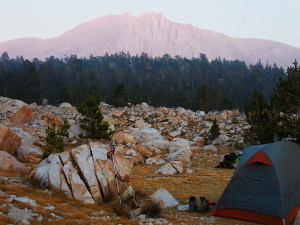
Tyndall Creek- Sunset
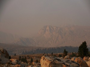
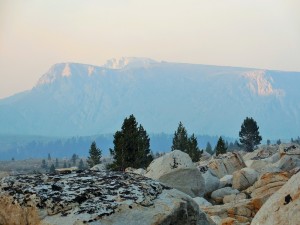
I love it here! I feel like I’m in a Star Trek episode: beamed onto a friendly alien planet where I get to explore the desolate moonscape-like terrain. My only wish is that this planet were free of the thick yellow smoke that hangs in the air so I could see the craggy mountainscape off in the distance. Oh well, it could be worse… I could be home in front of the TV dreaming of being on the trail! No need to beam me up Scotty, I’m good.
After hiking all day, trekking past a couple of small lakes and finally reaching the twisty Tyndall Creek which I had to cross multiple times, I found the few worn-down-to-the-dirt camping spots crowded together in the conifers on the left-hand side of the trail. I’m here! I made it! However, the vast and untouched boulder-strewn landscape that surrounded me beckoned to be explored; so I moved on. Being confined to that tiny area with everyone else isn’t exactly the wilderness adventure I came out here for.
I ventured up the trail and to the right, searching the several hundred feet of rocky terrain between the trail and the creek for my new temporary home. To my dismay, I was confronted by a string of “No Camping: Closed for Restoration” signs for at least a ½ mile. It seemed that no matter how far I hiked with my tired legs and heavy pack, I couldn’t escape the signs. Determined to find my own private piece of heaven I crossed the shallow, gently cascading waters of Tyndall Creek and headed toward the trail that leads to Shepherd Pass.
I easily reached the other side and did a quick visual scan: No signs! Awesome! I guess most people don’t bother to cross the creek to camp so no need for restoration. Treading lightly, I conscientiously searched for a spot where I would leave the smallest imprint to call home for the night.
When planning for this hike I saw Facebook posts, books and articles advising on the best camping spots on the trail. I scoffed at the idea of camping in worn out back-country campgrounds. For me, doing the John Muir Trail was about experiencing “true wilderness” as much as possible – much like John Muir did (despite the crowds I knew I’d encounter). My imagination led me to virgin spots where I could experience the natural, untouched solitude of life on the trail. Huddling in dusty camper corrals with everyone else, where a million people have camped before isn’t how my adventure played out in my imagination. I suppose that goes against my self-proclaimed Leave-no-Trace (LNT) Nazism a little bit, but I’m diligent and step carefully. I’m determined to enjoy unspoiled lands and leave no visible sign I was here for the next adventurers who seek the same.
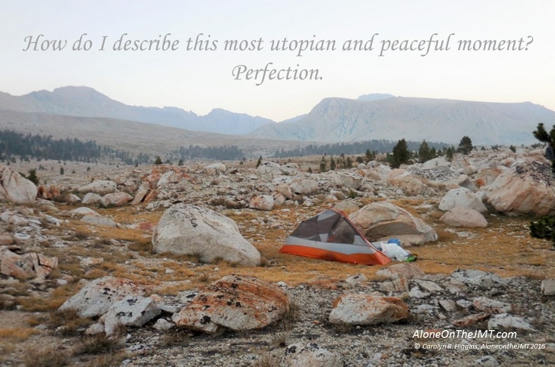
And now camp is set up more than 100 feet from the creek tucked away in the field of boulders of every size and shape, closer to the Shepherd Pass trail than the JMT. I pitched my tent on crushed rock, doing my best to avoid the short yellowish-brown tufts of grass that would be crushed underneath my weight. When I leave no one will know I was here.
I’m absolutely exultant. This place is magical, awe-inspiring, breathtaking and profoundly serene. I can’t wait to wake up to clear blue skies and the morning views that await. Like every other night out here so far, I’m optimistic that tomorrow I’ll wake up to another smoke-free morning. The smoke wasn’t as bad today as yesterday, but I saw it, still flooding the Crabtreee Meadow valley as I crossed Bighorn Plateau. I’m keeping my fingers crossed that it will only get better as I travel north.
The easy 8 mile day I thought I was going to have today turned out to be not–so-easy. I’ve made up my mind: the Tom Harrison Maps LIE! They lie about mileage and they especially lie about elevation. I swear I didn’t see all the elevation I climbed today on my map. I guess it could be I’m just not very good at reading those tiny little topo lines that are supposed to represent 40 feet intervals. 40 feet my ass – more like 4 HUNDRED feet. So I hiked mile after mile after mile this afternoon thinking, I should be there by now. Where is Tyndall Creek? Did I pass it already? Did I miss it somehow? Am I even on the John Muir Trail? Pulling out my map every mile or so to make sure I hadn’t missed an important turn off or walked right by my destination.
In my frustration I half-jokingly came up with a new business idea: I’m going to create my own maps. On my maps, all elevations and mileages will be exaggerated. For example: when you study your map to plan your day you’ll think you have 12 miles and 2000’ elevation gain to get to your destination, but it will actually only be 8 miles and 1000’. That way, you’ll be ecstatic when your destination is so much closer and easier than you expected! I’ll call them the “Surprise and Delight” maps with the tagline: “Hike further with less effort.” I know this “brilliant” idea is completely ridiculous, but it kept me amused on my alleged 8 mile hike today. 
The truth is, hiking is still hard. I’m still at 11,000’, my pack still weighs close to 40 lbs., I hiked 8 miles and a couple thousand feet today, and I’m 48, not 28. Stuff hurts! When will I earn my hiker legs? Day 7? Day 14? When??? Soon, I hope.
After meeting up with my friends from Arkansas at Wallace Creek today, I decided they need trail names. When I wasn’t trying to figure out how to launch a new business of fake maps, I spent much of my afternoon trying to come up with fun monikers for each of them. But in the end, the best I could do is a collective trail name: “The Arkansas Four”. I know, not very original… but I didn’t have the creative energy to name each one as I trudged up and over mountains carrying the ill-fitting pack they helped me adjust a little better at lunch. That led me to ponder how boring trail names would be if they were just the city or state we came from. I’d simply be “California” But there are lots of people from California. So maybe “Concord”- or “California number 15044”. Yah, I’d need to come up with something more creative for the Arkansas Four.
When I arrived at Tyndall creek I kept an eye out for the Arkansas Four, but didn’t see them. They must have gone on to Lake South America. In a way I was relieved (even though, I have to admit, I found myself eagerly searching every campsite for them). I had mixed feelings about running into them; I came to do this alone, I didn’t really want to have to make the decision to camp with them or not. This is better.
I met my first woman solo hiker today! I was ambling down a wooded trail somewhere between Crabtree Meadow and here when we crossed paths. I was so excited to see her that I practically lunged at her and shrieked, “You’re Alone!?!” She looked a little surprised (frightened?) and took a step back, probably thinking I was some wild old- lady lunatic. I realized it’s probably best not to greet solo female hikers in the middle of nowhere with what could be translated as: “Are you alone, little lady???” (insert malicious sneer). I guess she was convinced I didn’t have plans to eat her for dinner and stopped to chat with me a bit. She was half my age – if that – and didn’t seem nearly as impressed with the whole solo-female hiker sighting as I. She left Happy Isles 16 days ago and is finishing out of Whitney Portal tomorrow. Oh, the speed of youth! Anyway, I was thrilled to finally see my first solo female through-hiker. I hope to meet more.
***
I’m back from the creek now where I took a quick hiker bath and filled my Camelback and Nalgene bottle. The water is cool and crystal clear and fresh. I’m not going to bother treating the water in my Nalgene. I’m pretty high up and the water is flowing enough. I’ll mostly use it for making coffee and oatmeal and brushing my teeth in the morning anyway. Dinner is done and my Soloist pot washed. I’m enjoying my tea, sitting on a boulder soaking in the alpenglow views on the peaks to my north and east. How do I describe this most utopian and peaceful moment? Perfection.
Tomorrow is Forrester Pass- my first JMT Pass!!! A 5 mile, 2300 foot climb (or so Tom Harrison claims!) and then only 2-3 miles to my next camp somewhere in Vidette Meadow I think. I’m not really sure yet, I’ll see how my day goes… From there it’s on to Kearsarge Pass and Independence for my first resupply. Wow! It looks like I may end up there a day ahead of schedule. I finally fit all my food, toiletries and first aid items in my bear canister this morning and now I have to fill it up again in a couple days. That means one thing: I better eat up!
**SCROLL ALL THE WAY DOWN PAST COMMENTS AND CLICK TO READ THE NEXT POST! ***
so Im curious as Im planning a NOBO trip next year. Did you use bear boxes your first few days, an ursack, or how did you handle the extra smelly things that wouldnt fit into your bear canister? Or did you just hope that no critters or bears would bother you the first week?
Am inspired by your trip as I will be going solo also so I love reading about your trip.
Thanks
I love wandering thro these trails with you. I look forward to reading more and love your honest approach.
“Surprise and Delight” maps – love it. You could have a whole product line: put me on the pre-order list or the bathroom scale.
Barbara.. that’s funny! Thank you!
Wait, wait, wait! That’s it! What happens next?! Argh! Put me on your sub list. We have 21 days to go!
Yes, lots more to go! Thank you for reading!
I agree Jen!!! If this were a book I would not put it down! Love that you take us on your journey with you Carolyn! You keep me motivated to not give up on my dreams! Keep them coming!! 😉
Linnea,
I am so glad you’re enjoying the journey! I am way behind on posts but will have a new one (Forester pass) this weekend, I hope you continue to enjoy my story. Happy Trails! – Carolyn
As usual Carolyn, it’s another incredible episode in your great journey. I love the way you immerse the reader in your experiences. I’m looking forward to the next instalment
It’s really cool to know that I can put you right on the trail with me! Thanks again Brian. Happy Trails – Carolyn
Loving your journal. Thanks so much for writing it. Really enjoying how down to earth you are!
Barbara- I love your comments. Thank you very much for reading my blog – and especially for taking the time to write. The feedback inspires me to keep going. It’s an honor to know you enjoy reading. 🙂 Have a great week. – Carolyn
This is amazing and inspirational for me. Thank you so much
I’m so glad you’re inspired by this! Reading this is what keeps me writing. So thank YOU! Happy Trails!
Just a reminder, Carolyn. The reason everyone uses the same spots is to keep the impact to a minimum. And the signs apply to anything beyond them, so they wouldn’t be on both sides of the creek. I totally understand your desire to be where it’s pristine but the JMT gets so much traffic, it’s better to stay in well-worn spots. You might try other trails for the wilderness effect and not have to worry as much about your impact.
Thank you for the reminder Melinda.
I look forward to each and every post. Keep them coming!
Thank you Kathy! I’m so glad you’re enjoying my journey!